Overview & terminology
Over the years there have been a lot of unique terms and definitions tossed around when it comes to using GIS in asset management – especially in the utility and local government space.
Terms like GIS-Based, GIS-Centric, GIS-Integrated, Web-GIS-Centric, Modern-Web-GIS-Centric, and others have been coined by various folks, primarily companies trying to stand out and uniquely market their goods.
For our purposes we won’t get into the weeds of how different folks define things or how companies are trying to market themselves – we’ll just move forward with the assumption that you’re looking to leverage GIS in your asset management efforts and you’re currently trying to understand the different options you might have and how you might approach it.
What does it mean to use GIS for asset management?
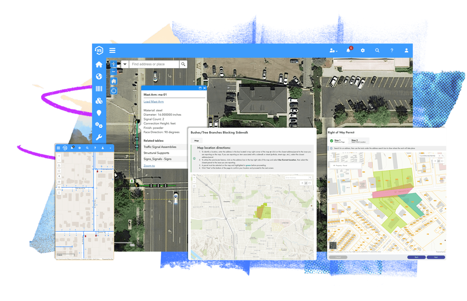
Using GIS for asset management combines asset management with modern web maps, offering the ability to spatially visualize locations of high risk assets, service requests, work orders, maintenance activities, expenditures, and more.
How is modern GIS integrated with asset management?
There are many ways this can be accomplished. Typically, this is either done by periodically synchronizing GIS data with asset management data or by using GIS data as the authoritative asset repository.
Synchronizing GIS with asset management
Many companies take this approach when building their asset management systems, primarily because it allows the asset management software to run completely independent of a GIS system – meaning even if you don’t have modern web maps or GIS, you can still use the asset management software.
In this case you’ve got two records for each asset – one record in the GIS and another record in your asset management software, and those records will synchronize data back and forth.
Pros: You can run the asset management software without a GIS system and it’s typically less expensive.
Cons: Synchronizing data is almost always a setback. Outdated information and the “who has the most recent and/or authoritative data” question often becomes a familiar struggle. Additionally, some asset management software requires a periodic upload of your GIS to the vendor's online platform, adding further complexities and synchronization issues.
Using GIS as the asset repository
To make this option work, the asset management provider has got to be all in with GIS. All in like the pig who gave you your bacon, not just semi-committed like the chicken who gave you your eggs… if you know what I mean.
In this case there’s only one record for each asset and that record is the GIS. There is nothing to synchronize, when you look at asset data (like the diameter of a water line or the color of a fire hydrant) you’re interacting directly with your GIS. The best asset management systems will even let you update your asset data that resides in the GIS directly from the asset management system using Esri authentication. High five.
Pros: No data duplication or synchronization, cleaner deployments, maximizes your your Esri investment
Cons: If you don’t have modern web maps or GIS yet, this won’t work for you (obviously). However, it doesn’t take much to get started and even if you’ve got nothing, you’re probably closer than you might realize to being able to start using a GIS-based system. Or GIS-centric. Or modern web-GIS. Or whatever you want to call it.
Using native Esri apps and tools for asset management
Of course Esri has their own stack of apps and tools that can be combined to create an asset management environment. In this case, apps like Workforce and Survey123 and Dashboards can be configured and combined to track work and related data directly against assets that reside in the GIS.
Pros: Native Esri tech and support as well as low-cost entry (these apps are probably free with your existing Esri licensing) make this option appealing.
Cons: Switching between the various Esri apps can get tricky – for example, to drive to a job and close out a request a field worker will, at a minimum, likely use three separate Esri apps: Workforce, Survey123, and ArcGIS Navigator. Additionally, the native Esri apps can take a lot of customization and configuration to do things beyond basic request and work order management. We love Esri’s native apps for a lot of reasons – but the amount of customization and configuration required to accomplish true asset management including inventory costs, business risk, maintenance schedules, and so on often means utilities and local governments will defer to Esri partners, like Novotx, who have already figured that part out.
Best practices for integrating GIS with asset management
With over 20 years experience, we can confidently state that the best practice for integrating GIS with asset management is to directly use your GIS as the asset repository. Every asset management user lines up with a corresponding Esri named user, GIS is the authoritative source for the asset repository, and the asset management software is the authoritative source for all asset management records including requests, work orders, maintenance, job costing, business risk, and so on.
Here at Novotx, we’re all in with Esri.
If you’d like to see how we do things, drop us a line. Until next time!